
Ebook
RIB CostX eBook – The Ultimate Estimating Solution

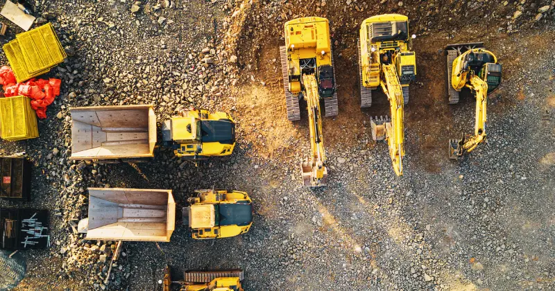
The foundation of a structure is often viewed as the first essential element of a build since the long-term stability of the entire building depends upon this fundamental layer. Before the first shovel hits the ground, another essential step must be completed successfully: a detailed site survey. This process provides insights into the size, constraints, and quality of a location, making it possible to launch a successful project. This guide explores the topic in detail!
A site survey gathers essential information on a specific area prior to beginning a project or renovation. The physical condition, topography, and environmental conditions of the site are reviewed to identify any important issues and pitfalls.
Site surveying involves intensive data collection using tools like tripods, digital levels, and soil augers to gather information on the boundaries, surface profile, and soil quality of the site, along with other factors of interest. This review must be detailed and accurate enough to support subsequent design and planning processes or influence on-site purchases, zoning, and viability decisions. The process doubles as a type of risk assessment since it is also used to identify construction hazards and obstacles.
Site surveys are performed for many different purposes. While some surveys are completed to support interior space remodeling or upgrades, others are performed to gather information on large, uncharted outdoor spaces. These different applications call for specialized types of site surveys.
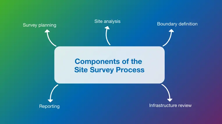
Site surveys can range from one- or two-day jobs with a small crew to months-long projects with multiple phases and specialists involved. Regardless of scope, here are the key steps to performing a site survey in construction:

Site surveys serve many important purposes beyond establishing accurate property boundaries. Construction surveying is essential for designers and civil engineers who rely on accurate survey data to complete their grading plans, building layouts, and landscape designs. Geological information from the survey helps ensure that structures and foundations can withstand disasters like earthquakes or hurricanes. Additional benefits that make site surveying essential include:
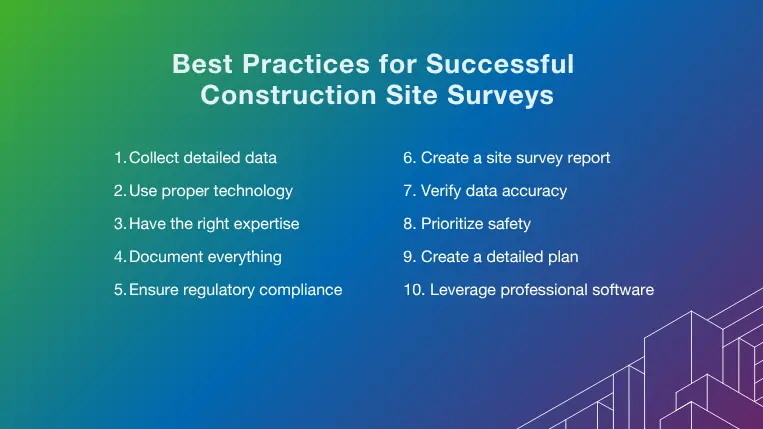
Site surveys vary in size and scope, but all feed into important decisions and outcomes with far-reaching impact. Following a few basic tips and best practices ensures that the results are as useful and accurate as possible.
A site survey may be the best (and only) opportunity to gather information from the location of interest; so, you can never collect too much data. This includes supplementing basic perimeter and topography information with soil composition and moisture content data. This granular data helps to support BIM designs and test processes. Information collected on factors like accessibility, utility locations, climate, and local traffic patterns also helps to support follow-on decisions and designs.
Digital construction technologies make surveys faster, easier, and more accurate with the development of tools like GPS mapping, drones, and total stations that accurately measure horizontal and vertical angles and distances. Small lots or interior surveys may not require advanced technology, but complex multi-acre surveys in remote or uncharted locations benefit from tools like GPR to review underground formations and drone mapping surveys to quickly gather aerial data.
A well-executed site survey combines data from various sources and tools to form a complete picture. Still, it is unlikely that any individual will have a depth of knowledge in all focus areas. The firm or consultant you hire should be well-versed in construction survey practices and regulations. Collaborating with experts in relevant fields like geology, seismic engineering, environmental science, and urban planning is important before, during, and after the survey.
Data collected during the survey is of little value if it is not organized for easy retrieval for reporting and compliance purposes. A complete set of records and documents makes it possible to maintain transparency between contractors, clients, and stakeholders regarding survey results while tracking any updates or changes that may impact the findings. These documents might include topographical maps, boundary and easement documents, environmental impact reports, and hand-written observations. Supporting yourself with professional construction document management software is fundamental to ensuring all documentation is saved and updated in a digital environment.
Sites should be checked against local building and environmental codes to ensure any proposed projects will be compliant with applicable laws. This includes verifying that all necessary permits are in place, that minimum distances from roads and waterways (setback requirements) are established, and that property lines coincide with existing deeds and titles.
Standard report formats include an introduction section explaining the purpose and scope and describing the methodology used to perform measurements and collect data. Maps, charts, and photos within the results section help to emphasize key findings and provide visual evidence of the site’s condition. The report should be written in a format that stakeholders with varying knowledge levels can easily understand; following construction reporting best practices is fundamental to this goal.
The results of the site survey form the foundation for the entire project. So, inaccurate data and conclusions can lead to a series of critical errors resulting in costly rework, schedule delays, or safety hazards. While digital surveying tools and software platforms like BIM eliminate many manual data transfer activities and calculations, it is still important to thoroughly review and verify survey results. This can be accomplished by repeating key measurements and calculations, cross-checking with different instruments, and utilizing independent reviewers to verify data accuracy or check for reporting errors.
Site surveys allow construction teams to explore new locations and facets of a proposed site for the first time. This presents opportunities to learn, as well as raise potential safety concerns. Construction hazards including slick surfaces, hidden trenches, asbestos, construction dust, and many other unforeseen conditions can appear unexpectedly during the surveying process; so precautions like personal protective equipment (PPE), communication devices, first-aid kits, and buddy systems should be utilized at all times.
Survey planning should be more than just a box check activity, since the speed and accuracy of the site survey are determined by the time and effort spent on planning. A detailed written plan must include the purpose, scope, and goals of the survey, along with the specific data needed to complete all tasks successfully.
Preliminary satellite images and drone photographs can be useful in determining what challenges might be encountered and what equipment is most appropriate. A comprehensive checklist within the plan helps ensure all required elements of the survey are completed and all team members understand their roles and responsibilities.
Modern technology has improved the collaboration, data analysis, and reporting aspects of site surveying, with construction software helping to streamline this essential process. RIB CostX is an all-in-one estimating, quantity takeoff, and reporting solution that provides multiple deployment options and error-free results to support surveyors and estimators. Carbon accounting capabilities enable long-term cost and environmental impact to be determined based on real-time survey and project data.
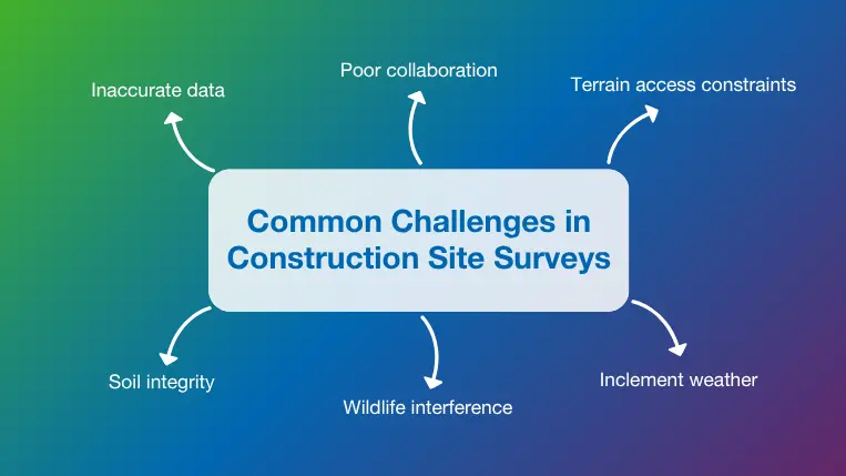
Advanced software tools and new technologies like robotic total stations, LiDAR, GPS, and drone surveying have taken much of the unpredictability and inaccuracy out of the surveying process, but there are still many challenges and unexpected issues that must be planned for and addressed to ensure the survey is completed on time and within budget. Some of the common challenges include:
FAQs about Construction Site Surveys
Surveyors are a familiar sight in most cities and developing areas around the world, with new surveys conducted to support development projects, or to baseline existing conditions and property lines. Let’s address some common curiosities about the challenges and specifics surrounding this activity.
Yes! A construction site survey can be extremely useful for resolving legal or boundary disputes, since it provides verifiable evidence of boundary line locations that make ownership rights easier to discern. This is especially useful in situations where pre-existing monuments like fences, buildings, or landscaping do not align with the actual property lines as defined by site maps.
In legal proceedings, an unbiased third-party survey provides the evidence needed to settle boundary disputes based on objective measurements, rather than opinions or assumptions. A survey conducted by a licensed surveyor is considered legally admissible evidence, which means judges can make decisions on boundary dispute cases based on these findings alone. This recognized legal status is also useful when formal or informal negotiations are needed to redraw boundaries or provide financial compensation for land use.
There is no pre-set duration for a site survey in construction, since the type, size and level of detail required all influence the amount of time and resources needed. For example, a survey of a small residential lot can often be completed in less than one day, while a large exploration survey might take several weeks or even months. Other factors that determine how long a survey will take include:
Site access can also be limited by active construction work, environmental sensitivities, or local limitations on working hours that make the surveying process move more slowly. In some cases, the existence of hazardous materials or other dangerous conditions like open pits, falling debris, or extreme temperatures can also increase the duration of the site survey.
The terrain and weather play a big part in determining how long construction surveying tasks take to complete, and they also impact the survey results in many other ways. For example, extreme temperatures can cause the ground and measuring equipment to expand or contract, creating slight variations in survey results. These variables must be considered when working in very hot or cold locations, especially when precise digital tools and equipment are unavailable.
Other weather conditions like humidity and high winds can make it difficult to calibrate equipment or establish an adequate line-of-sight between positions or monuments. Snow and heavy rain have an obvious impact since they obscure the ground and make it difficult to mark boundaries. These conditions can also distort results from GPR equipment.
The terrain impacts site surveying results in a similar way with features like steep slopes or thick vegetation obscuring site lines and making it difficult to set up equipment like tripods that require a consistent, flat surface. Canyons, tall buildings, and trees also interfere with the laser light and GPS satellite signals used by the latest surveying tools.
At the same time, soft or muddy terrain can cause equipment to sink or shift, which makes it difficult to produce accurate measurements. These unstable conditions can allow temporary or permanent boundary markers to migrate over time, making it necessary to repeat the construction surveying process. Construction drones are becoming a popular option to overcome some of these problems and potential errors presented by uneven or unstable terrain.
Before you can learn how to perform a site survey for construction correctly, you should understand what permits and licenses must be obtained to perform this work in accordance with industry standards and local regulations. The permits commonly required for surveying tasks include:
These permits ensure compliance with environmental laws to protect wildlife and other natural resources during and after the surveying process. An accurate survey helps to identify and prevent potential environmental impacts and avoid future legal consequences.
A land use permit provides evidence that a project complies with local zoning laws, building codes, and other regulations. A construction site survey is conducted in accordance with these regulations, while establishing a building envelope with appropriate drainage, fire access, and setbacks from property lines defined.
A building permit is required for almost any type of construction project, even those as simple as retrofits or remodels with no impact on the surrounding land and structures. As one of the first official project activities, the site surveying process requires a building permit to be obtained, while also allowing builders to produce a plot plan to prove compliance with local zoning regulations.
Site surveys use advanced equipment and software to capture a bounty of information from a select geographic area in a short period of time. With many important land buying, zoning, design, and environmental decisions relying on accurate survey results, there is no margin for error.
Construction software makes capturing, analyzing, and sharing important information in real time easier while making records and reports accessible to all stakeholders. If you want to learn how BIM 5D software can transform how you design, construct, and manage projects, get your free demo of RIB CostX today!

Get My Free RIB CostX Demo Now

The United Arab Emirates (UAE) is home to some of the world’s most ambitious construction projects. From record-breaking skyscrapers to…

Disconnected workflows between estimation, design, and execution are a leading cause of cost overruns in construction projects. This challenge is…

Today, organizations need reliable access to data across the board. This is important for small businesses, but enterprises are even…